Capo Smith
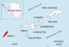
Il Capo Smith è un promontorio antartico che forma l'estremità settentrionale dell'Isola Smith, che fa parte delle Isole Shetland Meridionali, in Antartide.


Localizzazione
modificaCapo Smith è localizzato alle coordinate 62°52′25.5″S 62°18′00″W, 3,31 km a est-nordest del Matochina Peak, 12,85 km a est-nordest di Gregory Point, 4,16 km a est della parte settentrionale di Delyan Point, 2 km est-sudest dell'Isola Barlow e 40,5 km a ovest-sudovest dell'Isola Snow.
Mappatura bulgara nel 2009.
Denominazione
modificaLa scoperta delle Isole Shetland Meridionali fu riportata per la prima volta nel 1819 dal capitano William Smith, da cui il capo ha preso il nome.[1]
Mappe
modifica- Chart of South Shetland including Coronation Island, &c. from the exploration of the sloop Dove in the years 1821 and 1822 by George Powell Commander of the same. Scale ca. 1:200000. London: Laurie, 1822.
- L.L. Ivanov. Antarctica: Livingston Island and Greenwich, Robert, Snow and Smith Islands. Scale 1:120000 topographic map. Troyan: Manfred Wörner Foundation, 2010. ISBN 978-954-92032-9-5 (First edition 2009. ISBN 978-954-92032-6-4)
- South Shetland Islands: Smith and Low Islands. Scale 1:150000 topographic map No. 13677. British Antarctic Survey, 2009.
- Antarctic Digital Database (ADD). Scale 1:250000 topographic map of Antarctica. Scientific Committee on Antarctic Research (SCAR). Since 1993, regularly upgraded and updated.
- L.L. Ivanov. Antarctica: Livingston Island and Smith Island. Scale 1:100000 topographic map. Manfred Wörner Foundation, 2017. ISBN 978-619-90008-3-0
Note
modificaCollegamenti esterni
modifica- (EN) Cape Smith, in Geographic Names Information System, USGS.
- Cape Smith su geographic.org