File originale (11 570 × 9 714 pixel, dimensione del file: 27,73 MB, tipo MIME: image/jpeg)

Logo di Commons
Logo di Commons
Questo file e la sua pagina di descrizione (discussione · modifica) si trovano su Wikimedia Commons (?)
Attenzione Alcuni browser potrebbero avere dei problemi nel mostrare questa immagine a piena risoluzione: questa immagine è composta da un numero insolitamente alto di pixel e potrebbe non essere visualizzata correttamente o causare l'arresto del browser. Open large-image-viewer

Dettagli

Descrizione
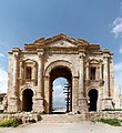
Deutsch: Der Triumphbogen (Hadriansbogen) im Süden der römischen Stadt Gerasa (heute: Jerasa) in Jordanien. Der dreiteilige Triumphbogen wurde laut Inschrift zum Gedenken an den Besuch Kaiser Hadrians im Winter 129/130 n. Chr. errichtet. Das Bauwerk ist 25 m breit und ca. 21,5 m hoch. Der Hauptdurchgang ist 6 m breit und knapp 11 m hoch, während die beiden seitlichen Eingänge 2,5 m breit und über 5 m hoch sind. Der Oberbau über dem Scheitelpunkt des Mittelbogens konnte seit den 1980er Jahren von der jordanischen Antikenverwaltung praktisch vollständig aus den heruntergefallenen antiken Trümmersteinen rekonstruiert werden (Quelle: Franz Rainer Scheck: Jordanien. Völker und Kulturen zwischen Jordan und Rotem Meer, DuMont Kunstreiseführer, Köln 1997, ISBN 3-7701-3979-8, S.163f.).
English: The Triumphal Arch (Hadrian's Arch) in the south of the Roman city of Gerasa (now Jerash) in Jordan. The tripartite triumphal arch was erected in commemoration of emperor Hadrian's visit to the city in 129/130 AD. The building is 25 m wide and ca. 21.5 m high. The main entrance is 6 m wide and 11 m high, while the side entrances are 2.5 m wide and 5 m high. The upper part above the peak of the main arch has been practically completely restored by the Department of Antiquities of Jordan by reusing the ancient ashlar around the arch (Source: Franz Rainer Scheck: Jordanien. Völker und Kulturen zwischen Jordan und Rotem Meer, DuMont Kunstreiseführer, Köln 1997, ISBN 3-7701-3979-8, p.163f.).
Data
Fonte Opera propria
Autore Askii
Altre versioni
Luogo dello scatto32° 16′ 19,77″ N, 35° 53′ 29,33″ E Kartographer map based on OpenStreetMap.Posizione di questa e altre immagini su: OpenStreetMapinfo

Licenza

Io, detentore del copyright su quest'opera, dichiaro di pubblicarla con la seguente licenza:
w:it:Creative Commons
attribuzione
Questo file è disponibile in base alla licenza Creative Commons Attribuzione 3.0 Unported
Tu sei libero:
  • di condividere – di copiare, distribuire e trasmettere quest'opera
  • di modificare – di adattare l'opera
Alle seguenti condizioni:
  • attribuzione – Devi fornire i crediti appropriati, un collegamento alla licenza e indicare se sono state apportate modifiche. Puoi farlo in qualsiasi modo ragionevole, ma non in alcun modo che suggerisca che il licenziante approvi te o il tuo uso.

Didascalie

Aggiungi una brevissima spiegazione di ciò che questo file rappresenta

Elementi ritratti in questo file

raffigura

32°16'19.76462"N, 35°53'29.32764"E

13.18119266055045871559 millimetro

image/jpeg

Cronologia del file

Fare clic su un gruppo data/ora per vedere il file come si presentava nel momento indicato.

Data/OraMiniaturaDimensioniUtenteCommento
attuale19:31, 17 set 2020Miniatura della versione delle 19:31, 17 set 202011 570 × 9 714 (27,73 MB)0m9EpCrop
14:14, 11 apr 2009Miniatura della versione delle 14:14, 11 apr 200912 391 × 13 562 (38,32 MB)AskiiOriginal resolution image
20:57, 23 mar 2008Miniatura della versione delle 20:57, 23 mar 20083 098 × 3 391 (4,35 MB)Askii{{Information |Description=Panoramic view of Hadrian's Arc, Jerash, Jordam |Source=self-made |Date=13.03.2008 |Author= Askii |Permission=See below |other_versions=n/a }}

Le seguenti 2 pagine usano questo file:

Utilizzo globale del file

Anche i seguenti wiki usano questo file:

Metadati