File originale (file in formato SVG, dimensioni nominali 1 100 × 837 pixel, dimensione del file: 546 KB)

Logo di Commons
Logo di Commons
Questo file e la sua pagina di descrizione (discussione · modifica) si trovano su Wikimedia Commons (?)

Dettagli

Descrizione
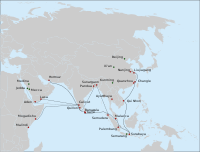
English: Some of the major long-distance military-diplomatic expeditions of the Yongle and Xuande reigns of the Ming Dynasty (1402-1435).

BLACK: Route of the 7th expedition of Zheng He's fleet (1431-1433).

  • Solid line: the route of the main fleet from Nanjing to Hormuz, as described in Xia Xiyang (下西洋).
  • Dashed line: a possible route of Hong Bao's squadron, to Bengal, Arabia and Africa, based on suggestions made in Dreyer (2007) (who uses Ma Huan's Ying-yai Sheng-lan (瀛涯胜览), Ming shi and other sources.
  • Dotted line: travel of 7 Chinese explorers, on an Indian (or Arab? vessel) and by caravan from Calicut to Mecca and Medina.
  • Red circles: cities thought to have been visited by the fleets of Zheng He, or the elements of the fleet, on the 7th and/or earlier voyages.
  • Green circles: important places in the biography of Zheng He, and Arabian cities visited by Ma Huan.

The previous 6 expeditions went along similar routes (the first 3, only to Calicut; 3rd through 6th, to Hormuz and other points in Africa/Arabia).

BLUE: Yishiha's expeditions from Jilin down the Sungari and the Amur to Tyr (Telin) (1411-1426)

GREEN: Approximate route of Chen Cheng, an envoy to the Timurid Empire (1414, 1416, 1420)

Sources:

The main source for Zheng He routes: chapter on the last expedition of Zheng He in: Dreyer E. L., Zheng He: China and the Oceans in the Early Ming Dynasty, 1405-1433. — Longman, 2007. — 256 p. — (Library of World Biography Series). — ISBN 0321084438.

The cities in Bengal are given as per : Barbosa, Duarte & Dames, Mansel Longworth (1996), An Account Of The Countries Bordering On The Indian Ocean And Their Inhabitants; Written By Duarte Barbosa And Completed About The Year 1518 A.D. Vol 1: Including The Coasts Of East Africa, Arabia, Persia And Western India As Far As The Kingdom Of Vijayanagar. Vol. Ii: Including The Coasts Of Malabar, Eastern India, Further India, China And The Indian Archipelago., Asian Educational Services, pp. 138-139, ISBN 8120604512

The routes of Yishiha and Chen Cheng are based on the descriptions in the articles "Isiha" and "Ch'en Ch'eng" in: Goodrich, L. Carrington; Fang, Chaoying, eds. (1976), Dictionary of Ming Biography, 1368–1644. Volume I (A-L), Columbia University Press, pp. 685–686, ISBN 0-231-03801-1
Русский: Дипломатические миссии эр Юнлэ и Сюаньдэ династии Мин (1402-1435).

ЧЕРНЫЙ: Маршрут 7-го плавания китайского флота под общим командованием Чжэн Хэ и Ван Цзинхуна (1431-1433 гг). Сплошная линия путь главного флота из Китая в Ормуз (известена достаточно достоверно); прерывистая - эскадра Хун Бао (предположительно); пунктир - путь 7 китайцев (включая Ма Хуаня) из Каликута в Мекку и Медину. Предшествующие 6 экспедиций двигались по сходным маршрутам (первые три, лишь до Каликута)

СИНИЙ: Плавания Ишихи по Сунгари и Амуру (1411-1432).

ЗЕЛЁНЫЙ: Три сухопутные путешествия Чэнь Чэна ко двору Тимуридов (1414-1420)
Data
Fonte Opera propria
Autore Vmenkov, based on the blank map File:Asie.svg (ver. 1) by User:Historicair
Altre versioni

[modifica]

A version that shows only Zheng He's expeditions:

Licenza

Io, detentore del copyright su quest'opera, dichiaro di pubblicarla con le seguenti licenze:
GNU head È permesso copiare, distribuire e/o modificare questo documento in base ai termini della GNU Free Documentation License, Versione 1.2 o successive pubblicata dalla Free Software Foundation; senza alcuna sezione non modificabile, senza testo di copertina e senza testo di quarta di copertina. Una copia della licenza è inclusa nella sezione intitolata Testo della GNU Free Documentation License.
w:it:Creative Commons
attribuzione
Questo file è disponibile in base alla licenza Creative Commons Attribuzione 1.0 Generico
Tu sei libero:
  • di condividere – di copiare, distribuire e trasmettere quest'opera
  • di modificare – di adattare l'opera
Alle seguenti condizioni:
  • attribuzione – Devi fornire i crediti appropriati, un collegamento alla licenza e indicare se sono state apportate modifiche. Puoi farlo in qualsiasi modo ragionevole, ma non in alcun modo che suggerisca che il licenziante approvi te o il tuo uso.
w:it:Creative Commons
attribuzione condividi allo stesso modo
Questo file è licenziato in base ai termini delle licenze Creative Commons Attribuzione-Condividi allo stesso modo 4.0 Internazionale, 3.0 Unported, 2.5 Generico, 2.0 Generico e 1.0 Generico
Tu sei libero:
  • di condividere – di copiare, distribuire e trasmettere quest'opera
  • di modificare – di adattare l'opera
Alle seguenti condizioni:
  • attribuzione – Devi fornire i crediti appropriati, un collegamento alla licenza e indicare se sono state apportate modifiche. Puoi farlo in qualsiasi modo ragionevole, ma non in alcun modo che suggerisca che il licenziante approvi te o il tuo uso.
  • condividi allo stesso modo – Se remixi, trasformi o sviluppi il materiale, devi distribuire i tuoi contributi in base alla stessa licenza o compatibile all'originale.
Puoi scegliere la licenza che preferisci.

Didascalie

Aggiungi una brevissima spiegazione di ciò che questo file rappresenta

Elementi ritratti in questo file

raffigura

Cronologia del file

Fare clic su un gruppo data/ora per vedere il file come si presentava nel momento indicato.

Data/OraMiniaturaDimensioniUtenteCommento
attuale01:34, 24 mag 2019Miniatura della versione delle 01:34, 24 mag 20191 100 × 837 (546 KB)AlphathonCorrected background positioning error
13:17, 25 ago 2010Miniatura della versione delle 13:17, 25 ago 20101 100 × 837 (857 KB)Vmenkov{{Information |Description={{en|1=Some of the major long-distance military-diplomatic expeditions of the Yongle and Xuande reigns of the Ming Dynasty (1402-1435). BLACK: Route of the 7th expedition of Zheng He's fleet (1431-1433). * Solid line: the rout

La seguente pagina usa questo file:

Utilizzo globale del file

Anche i seguenti wiki usano questo file:

Metadati