File:Post medieval, Anti-papist pipe tamper (FindID 525592).jpg

File originale (1 930 × 1 895 pixel, dimensione del file: 1,58 MB, tipo MIME: image/jpeg)

Logo di Commons
Logo di Commons
Questo file e la sua pagina di descrizione (discussione · modifica) si trovano su Wikimedia Commons (?)

Dettagli

Post medieval: Anti-papist pipe tamper
Fotografo
Berkshire Archaeology, David Williams, 2012-10-31 12:28:17
Titolo
Post medieval: Anti-papist pipe tamper
Descrizione
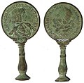
English: A complete cast copper alloy clay tobacco pipe tamper, now in two pieces. The head of the tamper is made using the design of a contemporary anti-papist medallion (diam.12.92mm) issued in 1678. The shaft of the tamper is of baluster form.

Side 1. The head of the pope in profile; when inverted he appears as the devil.

ECCLESIA.PERVERSA.TENET.FACIEM.DIABOLI The church subverted takes on the face of the Devil.

Side 2. Bust of Sir Edmundbury Godfrey facing right.

MORTENDO.RESTITVIT.REM.E.GODFREY E(dmundbury) Godfrey by his death re-established the state.

Godfrey was believed to have been murdered by Catholics on 12th October 1678.

Luogo rappresentato (County of findspot) West Berkshire
Data 1678
date QS:P571,+1678-00-00T00:00:00Z/9
Numero d'inventario
FindID: 525592
Old ref: SUR-0101B2
Filename: B12-370.JPG
Attribuzione
The Portable Antiquities Scheme (PAS) is a voluntary programme run by the United Kingdom government to record the increasing numbers of small finds of archaeological interest found by members of the public. The scheme started in 1997 and now covers most of England and Wales. Finds are published at https://finds.org.uk
Fonte https://finds.org.uk/database/ajax/download/id/402051
Catalog: https://finds.org.uk/database/images/image/id/402051/recordtype/artefacts copia archiviata at the Wayback Machine
Artefact: https://finds.org.uk/database/artefacts/record/id/525592
Licenza
(Riusare questo file)
Attribution-ShareAlike License version 4.0 (verified 22 novembre 2020)
Posizione del soggetto51° 29′ 32,64″ N, 1° 07′ 59,81″ W Kartographer map based on OpenStreetMap.Posizione di questa e altre immagini su: OpenStreetMapinfo

Licenza

w:it:Creative Commons
attribuzione condividi allo stesso modo
Attribuzione: The Portable Antiquities Scheme/ The Trustees of the British Museum
Tu sei libero:
  • di condividere – di copiare, distribuire e trasmettere quest'opera
  • di modificare – di adattare l'opera
Alle seguenti condizioni:
  • attribuzione – Devi fornire i crediti appropriati, un collegamento alla licenza e indicare se sono state apportate modifiche. Puoi farlo in qualsiasi modo ragionevole, ma non in alcun modo che suggerisca che il licenziante approvi te o il tuo uso.
  • condividi allo stesso modo – Se remixi, trasformi o sviluppi il materiale, devi distribuire i tuoi contributi in base alla stessa licenza o compatibile all'originale.

Didascalie

Aggiungi una brevissima spiegazione di ciò che questo file rappresenta

Elementi ritratti in questo file

raffigura

51°29'32.6"N, 1°7'59.9"W

image/jpeg

887a0ee474e38c7dfbb9b467e509d1a3e08a1e57

1 653 083 byte

1 895 pixel

1 930 pixel

Cronologia del file

Fare clic su un gruppo data/ora per vedere il file come si presentava nel momento indicato.

Data/OraMiniaturaDimensioniUtenteCommento
attuale15:25, 10 feb 2017Miniatura della versione delle 15:25, 10 feb 20171 930 × 1 895 (1,58 MB)Cropped 8 % horizontally and 15 % vertically using CropTool with lossless mode.
18:20, 30 gen 2017Miniatura della versione delle 18:20, 30 gen 20172 087 × 2 229 (1,62 MB)Portable Antiquities Scheme, SUR, FindID: 525592, post medieval, page 2406, batch count 10018

Utilizzo globale del file

Anche i seguenti wiki usano questo file:

Metadati