File:Tram map of Bochum and Gelsenkirchen.xcf

File originale (1 110 × 1 050 pixel, dimensione del file: 2,9 MB, tipo MIME: image/x-xcf)
| Questo file e la sua pagina di descrizione (discussione · modifica) si trovano su Wikimedia Commons (?) |
|
|
Dettagli
| Descrizione |
English: Tramway network of Bochum and Gelsenkirchen, Germany Deutsch: Topographischer Netzplan des Straßenbahnnetzes in Bochum und Gelsenkirchen |
|||
| Data | ||||
| Fonte | openstreetmap.org | |||
| Creatore |
OpenStreetMap contributors |
|||
| Licenza (Riusare questo file) |
OpenStreetMap data is available under the Open Database License (details). Map tiles are licensed under the Creative Commons Attribution-ShareAlike 2.0 license (CC-BY-SA 2.0).
Questo file è disponibile in base alla licenza Creative Commons Attribuzione-Condividi allo stesso modo 2.0 Generico
|
|||
| Georeferencing | If inappropriate please set warp_status = skip to hide. | |||
| Altre versioni |
 |

|
Questa immagine (categorizzazione automatica: city map) o tutte le immagini in questa categoria o galleria dovrebbero essere ricreate usando grafica vettoriale come file SVG. Questo offre diversi vantaggi: vedi Commons:Media for cleanup per maggiori informazioni. Se è disponibile una versione in formato SVG di questa immagine, per favore caricala. Dopo aver caricato un file SVG, sostituisci questo avviso con il template {{Vector version available|nome_immagine.svg}}.
|
Cronologia del file
Fare clic su un gruppo data/ora per vedere il file come si presentava nel momento indicato.
| Data/Ora | Miniatura | Dimensioni | Utente | Commento | |
|---|---|---|---|---|---|
| attuale | 17:42, 3 mar 2025 |  | 1 110 × 1 050 (2,9 MB) | Bürgerentscheid | cleaned |
| 10:13, 12 feb 2023 |  | 1 110 × 1 050 (2,9 MB) | Bürgerentscheid | Abzweig O-Werk ergänzt, ab 2023-01-09 | |
| 18:37, 1 nov 2020 |  | 1 110 × 1 050 (2,88 MB) | Bürgerentscheid | update 2020-11-01 | |
| 19:37, 11 gen 2020 | 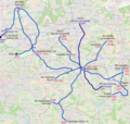 | 1 110 × 1 050 (2,88 MB) | Bürgerentscheid | Witten: track between Heven Dorf und Papenholz with regular circulation. | |
| 19:38, 21 dic 2019 |  | 1 110 × 1 050 (2,88 MB) | Bürgerentscheid | updated to 2019-12-15 | |
| 08:32, 14 apr 2013 | 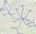 | 1 110 × 1 050 (3,01 MB) | Bürgerentscheid | {{XCF}} == {{int:filedesc}} == {{Information |Description=Tramway network of Bochum and Gelsenkirchen |Date=2013-04-14 |Author= Bürgerentscheid |Source= Openstreetmap |Permission= |other_versions=[[File:Tram map of Bochum and... |
Pagine che usano questo file
Nessuna pagina utilizza questo file.