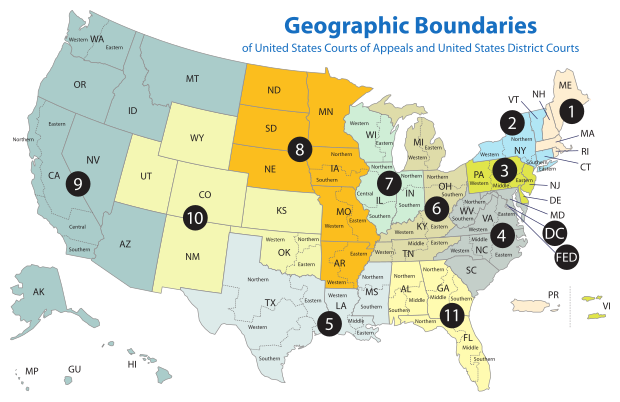
File:US Court of Appeals and District Court map.svg

Dimensioni di questa anteprima PNG per questo file SVG: 620 × 402 pixel. Altre risoluzioni: 320 × 207 pixel | 640 × 415 pixel | 1 024 × 664 pixel | 1 280 × 830 pixel | 2 560 × 1 660 pixel.
File originale (file in formato SVG, dimensioni nominali 620 × 402 pixel, dimensione del file: 768 KB)
Cronologia del file
Fare clic su un gruppo data/ora per vedere il file come si presentava nel momento indicato.
| Data/Ora | Miniatura | Dimensioni | Utente | Commento | |
|---|---|---|---|---|---|
| attuale | 19:58, 17 apr 2018 |  | 620 × 402 (768 KB) | BenbowInn | DC and FED are circuits too, added black circles to emphasize them, also converted to plain SVG |
| 08:48, 11 lug 2006 |  | 620 × 402 (1,14 MB) | Tintazul | {{Tintazul |Description=Map of the geographic boundaries of the various United States Courts of Appeals and United States District Courts. |Source=[http://www.uscourts.gov/image |
Pagine che usano questo file
Le seguenti 3 pagine usano questo file:
Utilizzo globale del file
Anche i seguenti wiki usano questo file:
- Usato nelle seguenti pagine di ar.wikipedia.org:
- Usato nelle seguenti pagine di bg.wikipedia.org:
- Usato nelle seguenti pagine di bn.wikipedia.org:
- Usato nelle seguenti pagine di ca.wikipedia.org:
- Usato nelle seguenti pagine di ckb.wikipedia.org:
- Usato nelle seguenti pagine di cs.wikipedia.org:
- Usato nelle seguenti pagine di da.wikipedia.org:
- Usato nelle seguenti pagine di de.wikipedia.org:
- Usato nelle seguenti pagine di en.wikipedia.org:
- Federal jurisdiction (United States)
- United States courts of appeals
- United States district court
- United States federal judicial district
- United States Court of Appeals for the Ninth Circuit
- United States Court of Appeals for the Eighth Circuit
- Case citation
- List of regions of the United States
- United States Court of Appeals for the First Circuit
- United States Court of Appeals for the Second Circuit
- United States Court of Appeals for the Third Circuit
- United States Court of Appeals for the Fourth Circuit
- United States Court of Appeals for the Fifth Circuit
- United States Court of Appeals for the Sixth Circuit
- United States Court of Appeals for the Seventh Circuit
- United States Court of Appeals for the Tenth Circuit
- United States Court of Appeals for the Eleventh Circuit
- United States Attorney
- United States Court of Appeals for the District of Columbia Circuit
- Circuit court
- United States District Court for the Southern District of New York
- United States District Court for the Eastern District of Virginia
- United States District Court for the Eastern District of Pennsylvania
- United States District Court for the Central District of California
- List of former United States district courts
- United States District Court for the Western District of New York
- United States District Court for the Eastern District of New York
- United States District Court for the Northern District of New York
- United States District Court for the Middle District of Alabama
- United States District Court for the Southern District of Alabama
- United States District Court for the Northern District of Alabama
Visualizza l'utilizzo globale di questo file.


