File:WVStatehoodVote.png
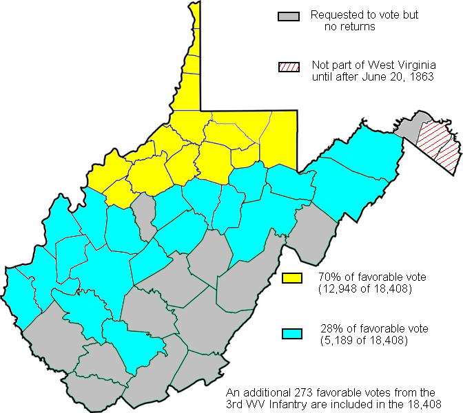
WVStatehoodVote.png (672 × 600 pixel, dimensione del file: 115 KB, tipo MIME: image/png)
Cronologia del file
Fare clic su un gruppo data/ora per vedere il file come si presentava nel momento indicato.
| Data/Ora | Miniatura | Dimensioni | Utente | Commento | |
|---|---|---|---|---|---|
| attuale | 18:19, 4 feb 2011 |  | 672 × 600 (115 KB) | Maproom | Repaired broken characters "a", "8". Reduced fringes from floodfill. |
| 02:11, 27 set 2009 |  | 672 × 600 (122 KB) | Dubyavee | Corrected some errors in numbers, noted small soldier vote | |
| 00:29, 27 lug 2009 |  | 672 × 600 (125 KB) | Dubyavee | changed Raleigh county from 'gray' to 'blue' to correct error in original. | |
| 00:11, 27 lug 2009 |  | 672 × 600 (125 KB) | Dubyavee | {{Information |Description={{en|1=Map created based on the voting results of statehood referendum on Oct. 24, 1861 in West Virginia as compiled by Richard O. Curry in "A House Divided", pgs. 141-152.}} |Source=My creation from data in R. Curry's "A House |
Pagine che usano questo file
La seguente pagina usa questo file:
Utilizzo globale del file
Anche i seguenti wiki usano questo file:
- Usato nelle seguenti pagine di fr.wikipedia.org:
- Usato nelle seguenti pagine di fy.wikipedia.org:
- Usato nelle seguenti pagine di ja.wikipedia.org:
- Usato nelle seguenti pagine di ko.wikipedia.org:

